
MathCityMap
How can we help pupils take a scientific look at the world? MathCityMap, a smartphone and tablet application, answers this question by hosting mathematics rallies. In these collaborative activities, pupils solve puzzles in groups. They must answer geolocated questions about objects in their surroundings, in their school, in the park next door, in their city…
MathCityMap is based on the maths trail idea introduced in Melbourne, (Australia) in 1984. At that time, the concept was available on paper only. Since that time, lots of mathematicians and math educators have picked up this fascinating idea.
MathCityMap is the result of a European project led by the MATIS I working group (IDMI, Goethe-Universität, Frankfurt) in collaboration with the University of Potsdam. The aim of MathCityMap is to create fun, touristic mathematics trails in European cities. The idea is to bring to life the presence and usefulness of mathematics in our everyday lives.
For instance, the rally “À l’abordage!” engages students into a math adventure about pirates. Pupils have to explore the harbour of Rochefort (France) to find clues and solve mathematical puzzles.
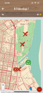
Abstract from “À l’abordage!”, a mathematical quest from “MathCityMap”
